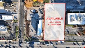
- For Sale $675,180
- Property Type VacantLand
- Lot Size 1 Acre
- Date Updated Apr 15, 2024
Want more info on this listing?
Reach out to the broker for more info on lease terms and amenities
False
Contacts

Arch Watson
SVN | Rankin Company
(417) 887-8826
Location
Getting Around
-
Walk Score ®
Car-Dependent (5) -
Bike Score ®
Somewhat Bikeable (25)
- City Republic, MO
- Neighborhood Republic
- Zip Code 65738
Points of Interest
-
Kum & Go (Trucks)
1.67 miles
-
Kum & Go (Cars)
1.70 miles
-
Shell
3.14 miles
-
Conoco (Cars)
3.29 miles
-
Conoco (Trucks)
3.30 miles
-
Kum & Go
3.41 miles
-
Murphy USA
3.56 miles
-
Flying J's
3.83 miles
-
Murphy USA
4.05 miles
-
Sinclair
4.08 miles
-
Ball Fields
0.88 miles
-
Wilson's Creek Trail
3.11 miles
-
Golf Course
3.28 miles
-
Paintball Parking
3.40 miles
-
Trail Parking (unpaved)
3.50 miles
-
1. Gibson's House and Mill
3.87 miles
-
8. Route of Union Advance & Withrawal (Parallel Parking)
4.02 miles
-
7. Bloody Hill and Totten's Battery
4.43 miles
-
2. Ray Farm
4.47 miles
-
Horse Trailer Parking
4.68 miles
-
Bair's All-American Sports Grill
2.93 miles
-
Arby's
3.24 miles
-
Wendy's
3.29 miles
-
Big Whiskey's American Restaurant & Bar
3.49 miles
-
Papa Murphy's
3.59 miles
-
Diamond Head
3.63 miles
-
Subway
3.64 miles
-
Little Caesars
3.65 miles
-
Wendy's
3.82 miles
-
I Love Tacos Taqueria
3.84 miles
-
Republic High School
2.38 miles
-
Willard Orchard Hills Elementary School
3.49 miles
-
OACAC West Chestnut Head Start
3.67 miles
-
Republic Middle School
4.08 miles
-
Lyon Elementary School
4.09 miles
-
Sweeny Elementary School
4.21 miles
-
Carver Middle School
4.22 miles
-
Price Elementary School
4.24 miles
-
Republic Early Childhood Center
4.25 miles
-
Schofield Elementary School
4.39 miles
-
Hope Childcare Center
4.18 miles
-
Macedonia Pre-School
4.61 miles
-
Safe N Sound Playground
5.15 miles
-
Isabel's House Crisis Nursery
5.19 miles
-
Where Families Grow
6.05 miles
-
Amazing Kidz Daycare & Preschool
6.21 miles
-
Creative Learning Center Preschool & Infant Care LLC
7.00 miles
-
OACAC Head Start
7.03 miles
-
OACAC Head Start
7.06 miles
-
Promise Pre-School & Day Care
8.17 miles
Contact Listing Broker

Arch Watson
SVN | Rankin Company
(417) 887-8826

